Click the map or link below to go to the Garmin Connect site.
 http://connect.garmin.com/player/4297665
1. In the map image on the Garmin site, select the "Terrain" box
2. Press the "Play" button
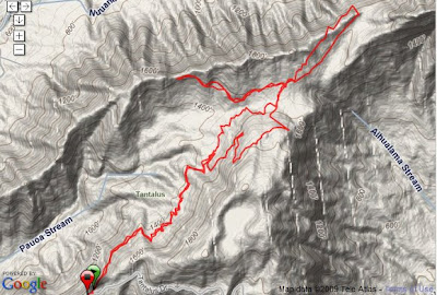
Mon, 4/20/09
Start: Parking #2
Trails: Kalawahine - Pauoa Flats - Nuuanu - Pauoa Flats - Manoa Cliff - Kalawahine
1:26 / 5.0 / 17:15 avg
Went to the Pauoa Flats lookout, where you can see the Pali Highway and into Kailua, then to the bench/grassy knoll on Nuuanu - my favorite trail.
Click the map or link below to go to the Garmin Connect site.
 http://connect.garmin.com/player/4297907
1. In the map image on the Garmin site, select the "Terrain" box
2. Press the "Play" button
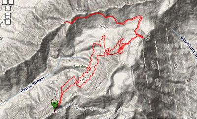
Wed, 4/22/09
Start: Parking #2
Trails: Kalawahine - Manoa Cliff - Pauoa Flats - Nuuanu - back
1:31 / 5.2 miles / 17:36 avg
Similar to Monday's run. My GPS watch was a little off - the beginning and end of the route were on the same (narrow) trail and should appear on top of each other (like on Monday's map). Strange.
Click on the map or link below to go to the Garmin Connect site.
 http://connect.garmin.com/player/4297090
1. On the map image on the Garmin site, select the "Hybrid" or "Terrain" box
2. Press the "Play" button
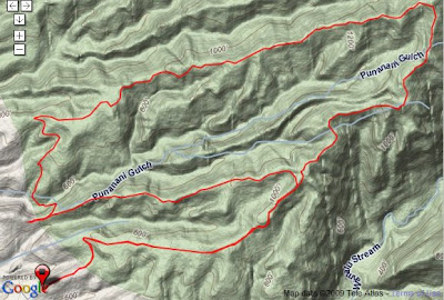
Sat, 4/25/09
Start: Pearl City
2:09 / 7.0 miles / 18:27 avg
Getting to know the trail that'll be used for the Run With A View race in 2 weeks. Looks pretty cool on the Terrain map. Great views throughout the run.
http://connect.garmin.com/player/42976651. In the map image on the Garmin site, select the "Terrain" box
2. Press the "Play" button
Mon, 4/20/09
Start: Parking #2
Trails: Kalawahine - Pauoa Flats - Nuuanu - Pauoa Flats - Manoa Cliff - Kalawahine
1:26 / 5.0 / 17:15 avg
Went to the Pauoa Flats lookout, where you can see the Pali Highway and into Kailua, then to the bench/grassy knoll on Nuuanu - my favorite trail.
Click the map or link below to go to the Garmin Connect site.
http://connect.garmin.com/player/42979071. In the map image on the Garmin site, select the "Terrain" box
2. Press the "Play" button
Wed, 4/22/09
Start: Parking #2
Trails: Kalawahine - Manoa Cliff - Pauoa Flats - Nuuanu - back
1:31 / 5.2 miles / 17:36 avg
Similar to Monday's run. My GPS watch was a little off - the beginning and end of the route were on the same (narrow) trail and should appear on top of each other (like on Monday's map). Strange.
Click on the map or link below to go to the Garmin Connect site.
http://connect.garmin.com/player/42970901. On the map image on the Garmin site, select the "Hybrid" or "Terrain" box
2. Press the "Play" button
Sat, 4/25/09
Start: Pearl City
2:09 / 7.0 miles / 18:27 avg
Getting to know the trail that'll be used for the Run With A View race in 2 weeks. Looks pretty cool on the Terrain map. Great views throughout the run.


No comments:
Post a Comment