Friday, December 24, 2010

Peacock 54: 10/23/2010

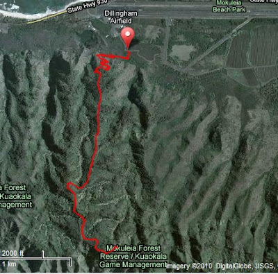
Map created by Sean Price and Mike Muench for HURT Hawaii

'Twas the night before Peacock, when all through the hale,
I was still stirring, preparing for tomorrow's folly.

The drop bags were staged by the front door with care,
In hopes that at an aid station, I'd find them there.

The pacers were nestled all snug in their beds,
While visions of running danced in their heads.

I was still awake, trying not to make a clatter,
I couldn't go to sleep. I don't know what was the matter.

Our training runs were done - Jan and I flew like a flash,
Our one-loop time was an hour faster than the year past.

The race started at 6, the sun started to appear,
Everyone knew high temperatures soon would be here.

The runners reached the top of Kealia Fire Road, and they took off quick,
I tried not to go with them - I wanted to finish with a kick.

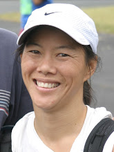
Another girl was running with us, Deanna was her name,
She called Oh Sh*t Hill 'Awesome' - she was up for the game.

Julie, Jan, Deanna (photo by Rob Lahoe)

On Crossover, on Long Road, and the much-anticipated aid station,
Then back up Long Road at mid-day - watch out for dehydration.

But Jan started struggling, she was hitting the wall,
I kept going on; but breaking up J-squared - it truly felt awful.

Deanna and I headed back towards Dillingham, so we could start Loop 2,
Coming down the switchbacks, we practically flew.

Down at the parking lot, our pacer, Brad, was found,
He planned to run with us - the whole loop around!

We started up the Kealia switchbacks and then Kealia Road,
The second time up the steep hills - our pace was definitely slowed.

We went around Gordon's Loop again, the sun was making us fry,
Upon reaching Rob's aid station, all three Camelbaks were dry.

Brad was the perfect pacer; we set the pace, he stayed in the back,
But on the flats and downhills, he kept us running; he wouldn't cut us any slack.

At the bottom of Long Road, there was pizza and the mood was merry,
We were happy to see Jan still going - her determination was scary.

We made it up Long Road again; but on Crossover, Deanna started to slow,
Brad and I kept going, pushing hard to Rob's aid station, which was all aglow.

We finally reached the finish - I was exhausted and dirty,
I had run all day and all night - finished at 9:30.

Gordon was sitting - he organized the race plus ran all day,
But as I was leaving, I heard him clearly say:

Congratulations to all! Next year it's a 100K!

Julie, Brad (photo by Doug Baker)

Sat, 10/23/10
Start: Dillingham Airfield (North Shore)
Loop 1: 7:15
Dillingham aid station 0:15
Loop 2: 7:58
Total: 15:28 / 54 miles / 17:11 avg

Race write-up, results, and course map on the HURT Hawaii website.

Saturday, August 21, 2010

Kaena Point Firecracker: 7/3/2010

The Kaena Point Firecracker 10 mile race is held on Fourth of July weekend (I know, I know, my blog is way behind).

The race starts on the North Shore, runs around Kaena Point (the northwest corner of Oahu), and continues on the West side to Yokohama Bay. The course is flat and usually dry and hot. This year there was...MUD.

On the West side, there were mud puddles that took up the whole path. And since it's an out-and-back race, it made it a little tricky trying to navigate around the runners coming back towards you.

Of course, it was the usual fun run. And yummy food afterwards. Have you figured out the whole reason I run is for the food? If you've ever been to a HURT-sponsored run, you know what I mean - the food is always awesome!

Brad and I ran the race together

Brian paced off Lisa for the way out

Then ran the way back with Arvel

Jan was smiling, as usual

To make the run an even 10 miles, after you start at the 'rock', you have to run a little extra section up to the paved road, around a telephone pole, then back to the dirt road. The end of the race is when you get back to the rock. My Garmin measured it as 9.97 miles!

http://connect.garmin.com/player/39972973
1. On the map image on the Garmin site, select the "Hybrid" box
2. Press the "Play" button

Sat, 7/3/10
Start: End of Farrington Highway (North Shore)
Trails: Kaena Point (North Shore to Yokohama Bay and back)
1:37 / 10.0 miles / 9:42 avg

Race write-up, results, and more pics on the HURT Hawaii website.

All photos by HURT Hawaii.

Sunday, August 8, 2010

San Diego 100 - Pacer report

I wasn't sure whether or not to do a post about the San Diego 100. One, because it was Jan's race, not mine. But mostly, because Jan has already written an AWESOME race report. Check it out:

Jan's San Diego 100 Race Report

But after telling the story of the race multiple times, I finally decided I should write it down.

PREPARING

Jan had a chance to run the San Diego 100, an ultramarathon in the mountains east of San Diego. I was able to use my frequent flyer miles to get to San Diego and afterwards to SFO to visit my family - so I went along to pace Jan for the last 50 miles of the race.

I am always amazed how long it takes to get ready for an ultra. I don't mean the obvious - training. But also studying the course maps, deciding what to bring, and figuring out what to put in the drop bags for each aid station (food, electrolytes, clothes, lights, batteries, etc.).

Jan studied the detailed course breakdown on the SD 100 website, including distance and elevation gain/loss between aid stations and cutoff times. She came up with estimated arrival times for each aid station, which was our main plan. Her schedule also allowed us to figure out which aid stations to leave drop bags at and what to put in each of them.

I found that the SD 100 website includes Garmin routes for the course. Perfect! The course has multiple loop sections and "following" the course and elevation chart on the Garmin Connect Player was much more clear than trying to understand all the multi-colored arrows on the topographical maps.

San Diego 100 course (Garmin data from SD 100 website)
http://connect.garmin.com/player/34598704
1. In the map image on the Garmin site, select the "Terrain" box
2. Press the "Play" button


CREWING

The race start is at 5700 feet. Jan and I needed some warm clothes and borrowed the coolest vests from her brother. At 5700' at 6am, it was COLD!

Jan, Ryan, Julie (photo by Ryan Gillia)

After seeing Jan, Ryan, and Ryan's friend, Rachel, off at the start, I was able to catch a ride with Alan, Rachel's boyfriend. Alan and I would drive to each aid station, park the car, lug all the stuff to the aid station, wait for the runners to get there, then refill their hydration packs, get them sunscreen, food, different clothes, etc.

I also tried to rest and stay off my feet, so that I'd still have energy by the time I was supposed to start pacing, somewhere around 8-9pm. Thanks to Alan, I managed to catch a couple of naps in the morning, which was a huge help.

Jan at mile 23

After Jan, Ryan, and Rachel got through the mile 23 aid station (Penny Pines) around 1pm, the next aid station that was accessible to crews was mile 44 (Pioneer Mail). Rob, another of Ryan's and Rachel's friends, showed up, so Alan, Rob, and I spent the afternoon hanging out at Pioneer Mail.

Rob and Alan at Pioneer Mail

The stage with the biggest climb was just before mile 44. Many of the runners came into the Pioneer Mail aid station shaking their heads, cursing.

Elevation map from SD 100 website

Ryan and Rachel got to Pioneer Mail around 6:15pm. Jan had been expecting to get there at 5:45pm, but wasn't there yet. Alan had to leave to meet Ryan and Rachel at the next aid station, so Rob and I stayed and waited for Jan. As it started getting later and darker, I was getting more worried. I kept checking with the aid station staff to see if they knew what time Jan left the previous aid station, but all they could tell me was that she hadn't dropped yet.

I was so glad when Jan finally arrived at Pioneer Mail (mile 44). Even though she had just finished a super-tough section and was behind schedule, she was still smiling. Amazing! She even had a plan already figured out. Pacers aren't allowed to start until mile 51. But since it was already 8:15pm and there was no way she'd make the 9pm cutoff at mile 51, Jan asked me to run with her to the next aid station. She'd break 50 miles and I'd get a chance to run! I was already excited to see that Jan still had a positive attitude! And now I was really excited to get out on the trails!

I threw all my stuff at Rob to take to the next aid station and grabbed my flashlights. Rob also generously lent his fleece jacket to Jan, since the darkness was causing it to get cold.


PACING

Jan and I took off on the trail. It was just after sunset and the views across the mountain desert were amazing.

About 30 minutes in, we came across another runner, "T". She was panicky - she complained about double-vision and not seeing enough course markers to know if she was on the right trail. We calmed her down somewhat and T asked whether she could continue with us. Jan and I definitely agreed that she shouldn't be out on the course alone and the three of us continued towards the mile 51 aid station (Sunrise) together.

As we continued, it became more evident that T was really struggling. She still complained about her vision and was literally leaning on me for every step. And she was still a little panicky. Jan and I tried to keep her talking. I gave her Gatorade/water and Clif bar (2 of her 3 water bottles had been empty). Her hands were very cold, she was shivering, and her speech was slurred. At this point, I gave her my vest and tried to call the aid station staff. I wanted to get advice to see if there was anything else I should be doing for T, but I also didn't want to scare her more.

I called Alan, who was already three aid stations ahead, and asked him to relay a message to the Sunrise aid station and have someone call me. Unfortunately, cell reception was spotty and they weren't able to reach me.

Jan, T, and I finally made it to Sunrise (mile 51) about midnight - 4 hours after we left Pioneer Mail (mile 44). We got T to the aid station staff, who put blankets around her, got her warm soup, and put her next to a heat lamp. Luckily, there was a volunteer EMT there and he did a GREAT job of calming T down.

We also had to get Jan warmed up. Because the pace was so slow helping T, it caused Jan to get really cold. We got Jan a blanket, soup, and put her next to the campfire.

Thankfully, Rob had waited for us at Sunrise. He still had all of my stuff in his car and he drove us back to our car at the race start. In addition to loaning Jan his jacket, this was the second time he saved us.


SUMMARY

So, at the end of the (very long) day, I got more practice getting organized for an ultra, I had a fun day hanging out with Alan and Rob amidst some amazing scenery, and I got to spend a few hours on the trail at night.

I was also impressed with Jan's determination:
- She accomplished her first goal: getting to the starting line on-time
- She didn't let a setback of a tough stage get her down
- She kept giving positive motivation to a fellow ultrarunner, despite being cold and tired herself
- And she completed 50 miles

In retrospect, Jan and I should have done a more thorough initial assessment of T and then taken her to the nearest aid station (which was back to Pioneer Mail), rather than agreeing to let her come with us to Sunrise. I thought T was just scared and would be better once she calmed down. I truly didn't expect that someone in so much trouble would be out on the trail.

Sunday, July 4, 2010

Tai's Going Away Run - Nuuanu

Fish, Gordon, Annie, Lisa, Cindy, Tai, Jack, Julie

Tai completed UH grad school and was offered a great opportunity in Washington State. To say 'Goodbye' and to congratulate Tai on her graduation, we celebrated with a run. And food.

We started at Jackass Ginger trail, followed by a climb up Nuuanu trail to the bench. As Tai would say, the climb was 'glorious.'

Julie, Annie, Tai, Cindy

Lisa, Jack

Gordon, Fish, Tai

After the run, we headed over to Bangkok Chef and met up with Brad and Ernest for some yummy Thai food. And dessert from Diamond Head Market & Grill. Tai introduced me to this awesome oreo cookie -peanut butter-banana-chocolate pudding-whipped cream concoction.

Tai, Ernest

http://connect.garmin.com/player/37621383
(Garmin data courtesy of Lisa Reinke)
1. In the map image on the Garmin site, select the "Hybrid" box
2. Press the "Play" button

Thu, 6/3/10
Start: Jackass Ginger
Trails: Jackass Ginger - Nuuanu (out & back)
~1:15 / ~4 miles (lost satellite reception on the way back)

Sunday, June 27, 2010

Raging Isle Sprint: 6/26/2010

First, a little background...

Garmin recently added a Swim mode software update for the Forerunner 310XT. There was a post about it on the Garmin blog, which also included a link to DC Rainmaker's blog.

Not only did DC Rainmaker have an incredibly in-depth review of the new Swim mode, but one of his earlier posts also shows how to swim with the Forerunner 305 in a swim cap!

Why didn't I think of that???

The Raging Isle Sprint is the first race in the 2010 North Shore Swim Series. I decided to try out the Garmin in a swim cap method.

I pretty much followed DC Rainmaker's tips:
- Remove the watch from the watchband
- Put the watch inside a ziploc bag
- Put the watch/ziploc bag on your head and put on your swim cap

I did have to make a few adjustments. The 405 has a bunch of sharp points and buttons and they kept poking holes in the ziploc bag, so I had to cushion all the pointy parts first (the 305 and 310XT are more square and their buttons are on top). Plus it was kinda hard to stuff the watch into my swim cap along with my ponytail. But Brad suggested putting the watch in the swim cap first, then putting the cap on my head. That was much easier.

The Swim

There was a North Shore swell on the day of the Raging Isle Sprint, so the race organizers put out buoys along the whole course to keep swimmers further outside and away from the shallow reef (and out of the way of the surfers).

When they sounded the horn, I pressed the Start button and started swimming. And kept swimming (just keep swimming...). It seemed like it took forever.

Then my watch beeped. At first, I thought I accidentally stopped it. But then I realized it was the 'Auto Lap' feature - I had swum a mile.

Raging Isle is supposed to be a 1-mile swim, but the Garmin recorded 1.2 miles. Surprisingly, the GPS route on the map looks pretty straight (when I'm swimming, I feel like I'm zig-zagging all over the place). And if you zoom in, you can really see the reef underwater.

Race Results can be found here.

Many THANKS to Jake from Garmin for alerting me to the new Swim mode, DC Rainmaker for the How To guide, and Raging Isle and Waikiki Swim Club for putting on a fun swim!

http://connect.garmin.com/player/38292439
1. In the map image on the Garmin site, select the "Hybrid" box
2. Press the "Play" button

Sat, 6/26/10
Start: Sunset Beach
Finish: Pipeline (Ehukai Beach Park)
0:52:35 / 1.0 miles / 3:17 per 100m

Friday, June 25, 2010

Jan's Birthday Run - Kaena Point

To celebrate Jan's Birthday, a group of us — Andy, Jan, Brad, Annie, Arvel, Lisa, Johnny, Benita, and me — went on a run at Kaena Point and had a potluck brunch afterwards. Jan's birthday was actually back in April - but it took me a while to put the run/potluck together. And even longer to post the pics and route.

Brad at the Point, with the Waianae range in the background.

At the Point, we saw a snoozing monk seal.
And a juvenile albatross.

Jan, Johnny, Andy

Annie, Lisa, Arvel

Johnny & Andy, along the coast

Everyone brought lots of good food! (photo by Johnny Landeza)

http://connect.garmin.com/player/37619867
1. In the map image on the Garmin site, select the "Hybrid" box
2. Press the "Play" button

Mon, 5/31/10
Start: End of Farrington Highway (North Shore)
Trails: Kaena Point: North Shore to Yokohama Bay (almost) and back
2:08 / 8.9 miles / 14:17 avg

Sunday, June 20, 2010

Run With A View: 5/8/2010, plus Peacock

Oops, I need to catch up on my posts...

Run With A View: Third race in the 2010 HURT Trail Series. In May.

008
View of Arizona Memorial (photo by Rob Lahoe)

As we started up the hill, there was a nice rain shower. I ran with Brad, Tai, Gordon, and Fish for awhile. Then we came across Jan, who was struggling with a strange, possibly allergy-induced, asthma attack. I stayed with Jan as she pulled herself back together and finished strong. Impressive.

http://connect.garmin.com/player/33419845
1. In the map image on the Garmin site, select the "Hybrid" box
2. Press the "Play" button

Sat, 5/8/10
Start: Pearl City
Trails: Kaahele
1:54 / 8.3 miles / 13:48 avg


Afterwards, Jan, Tai, and I headed up to Peacock for some more fun. We still had our race numbers from Run With A View on our legs. And people kept asking us how we got so dirty.

Julie, Tai, Jan

The three of us completed the Peacock 54-mile race together last October, so it was nice to be up there one last time before Tai moves away. And of course, there were the usual nice views.

Yokohama Bay

http://connect.garmin.com/player/33419908
1. In the map image on the Garmin site, select the "Hybrid" box
2. Press the "Play" button

Sat, 5/8/2010
Start: Dillingham Airfield
Trails: Kealia Trail - Kealia Fire Road - Crossover to three-way & back
2:39 / 7.0 miles / 22:32 avg

Wednesday, May 26, 2010

12 Hours of Makawao: 5/22/2010

Jan and I flew over to Maui for the 12 Hours of Makawao - a low-key event put on by the Valley Isle Road Runners at Kahakapao trail, a 6-mile loop in the Makawao Forest Reserve. Participants can run or mountain bike or both. For a few hours or all day.


Our original plan was to try to complete 8 loops (~49 miles) in 12 hours. But it turns out that the gate to the parking lot is only open from 7am-7pm. So realistically, that only gave us ~11 hours of running time.

Tom, the event director, graciously met us early and led us up the hill to the parking lot. We met some of the other runners and bikers and then were on our way at 7:20am.


Two of the local runners, Jackie and Marsha, were kind enough to show us the way on the first loop. It's a 0.5 mi dirt road from the parking lot to the Kahakapao trailhead. Then ~5.6 mi loop - up the East Loop to the top for the first half, then back down the West Loop. The trail has switchbacks up and down, so it's a gradual climb and a gradual downhill. Definitely a run-able grade, although we walked most of the uphills, since we were there all day.

The trail is very well-marked, with mile markers every half-mile and blue arrows on the trees to point the way. Since the trail is in the forest, the trail is leaves, pine needles, and soft dirt. A very forgiving surface and not at all rooty or rocky like Tantalus trails. And this past weekend, the trail was dry and in perfect condition.

Jan

Julie

http://connect.garmin.com/player/34599912
1. In the map image on the Garmin site, select the "Hybrid" box
2. Press the "Play" button


We would run 2 loops, then return to the car to restock. The Garmin route shows our first 4 loops (before the battery on my Forerunner 405 ran out). And the elevation map shows how consistently the trail is graded.

All in all: We completed 37 miles in 10.5 hours. On an amazing, amazing trail. At an easy, self-supported event. Can't wait for next year! Tom promises it'll be "even more low-key."

Splits (by loop):
1      1:28
2      1:41
break  0:05
3      1:39
4      1:41
lunch  0:19
5      1:59  (picture-taking loop)
6      1:44
Total: 10:36 / 37 miles / 17:11 avg

Gear:
- Asics Trabuco trail shoes
- Thorlo running socks
- Running Funky gaiters
- Camelbak (1.5L / 50 oz)
- 2 Clif bars
- 2 packs gummi bears
- 1 peanut butter and jelly sandwich
- 1/2 orange
- 2 bags pretzels
- McDonald's french fries (delivered by Brad and his Dad!)
- 11 Thermotabs / S-caps
- 75 oz (0.6 gal) Gatorade
- 75 oz (0.6 gal) water


The aftermath

Sunday, May 16, 2010

Haleiwa Metric Century Ride (4/09)

Here's the route from last year's Haleiwa Metric Century Ride. This year I was out of town and wasn't able to do it, but it's one of my favorite rides. Last year, my friends Mark and Jane were visiting, so Mark decided to do the Metric Century with me.

The Metric Century starts in Haleiwa and goes along the coast past Laie, out to Swanzy Beach Park in Kaaawa, and then back. And with the morning light over the water in so many places - you get so many super-amazing views.

http://connect.garmin.com/player/4414202
1. In the map image on the Garmin site, select the "Hybrid" box
2. Press the "Play" button

Sat, 4/26/09
Start: Kaiaka Bay Beach Park, Haleiwa
Turnaround: Swanzy Beach Park, Kaaawa
3:47 / 55.5 miles / 14.7 mpg avg


The Haleiwa Metric Century Ride is put on by the Hawaii Bicycling League (HBL). Their website has these very cool, point-of-view (POV) videos of what it's like to ride on streets on Oahu. Check out this video going up Monsarrat Ave:


For links to all Oahu Bicycle Routes.

You can also view the maps including bicycle crash data, such as:
Map 1. Downtown Honolulu, Ala Moana, University

Wednesday, April 14, 2010

Eco-Trail de Paris 50k - Lisa's race report

Lisa and her friend, Carol, flew to France to run a 50k trail race. The Eco-Trail de Paris 50k goes from Versailles to Paris and finishes at the base of the Eiffel Tower. How cool is that?


A few days before the race, Lisa emailed me a picture of her breakfast. I was drooling...
Petit dejeuner

Here's Lisa's race recap:

We finished! It was a mud fest and felt like 14 Hogsbacks in a row. Harder than the Volcano Marathon. I was doing good up to 40k @ 4:31, but then shuffled to the Eiffel Tower. Finished in 5:54. Carol was 5:36. Oh, we first had to walk a mile to catch the train to Versailles then walk 4k around Versailles Gardens to the race start line. So it was like a 55k! Lucky the rain stopped just as race started. It was a downpour for 15 hours before. The mud was crazy!

1 min. to START

at 10k - trudging up through the mud

Aid stations had chocolate! We are now having champagne and chocolate macarons.
Mmm, and fromage too

See attached Garmin data. You can see where the Garmin lost mileage in spikes of speed and I also recall looking at my Garmin 4-5 times and seeing it searching for satellites, lost signal.

4,500 feet of elevation gain (this is in garminconnect.com)....and when I downloaded to the Garmin Training software, it posted 7,000+ feet of elevation gain. It felt like 10,000!. Who knew if was going to be 20 times 200-foot hill gains. It was a Hogsback repeat race after all!


Race Required Gear:
- 2 liters water minimum (Nathan HPL Hydration 008 race vest with a 45+ oz Camelback bladder with electrolytes plus a Nathan 9 oz handheld bottle).
- Personal cup 15cl minimum
- Food supply (for me: 6 Tri-berry Gus, a few pretzel sticks, 1 pkg Clif Shots, 1 scoop Spiz)
- Rain Jacket
- Tights (CW-X)
- Trash keeper (race-provided mesh holder for your sports gu trash).
- Cell phone
- Reflective arm band
- Whistle
- Survival blanket!!!?
- Adhesive elastic band enabling you to make a bandage or strap (mini 80cm x 3 cm)
- Cap or bonnet (“buff”)
- Proof of identity (Road ID)
- Medical certificate (“fit for competitive running”)

Other personal gear:
- Salomon XA Pro 3D Ultra trail shoes
- Long-Sleeve jersey
- SmartWool socks
- Electrolyte tab and Advil
- Map of race course
- 10 euros

My gear + water stuffed into the Nathan vest weighed 6 lbs! But very comfortable the entire race.

Links:
- More of Lisa's Paris pictures
- Eco-Trail de Paris site
- Blog post from 80k 4th place finisher, Ian Sharman

All photos by Lisa Reinke.