Friday, August 14, 2009

Brian Clarke's Trail Training: 2009, week 11

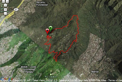
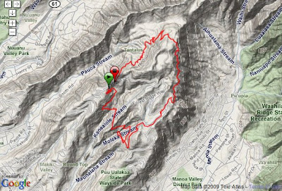
I missed Week 10 of the Training, because I was hiking the Kalalau Trail on Kauai (route and pics to come). I returned for Week 11 - and for some climbing. Wednesday night's run went down to Jackass Ginger and back up. Saturday's run/hike went to the top of Mt. Kaala, the highest peak on Oahu.

Click the map or link below to go to the Garmin Connect site.
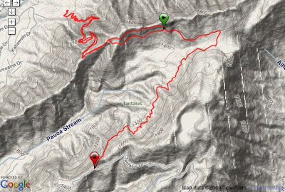
http://connect.garmin.com/player/8590234
1. In the map image on the Garmin site, select the "Terrain" box
2. Press the "Play" button


Wed, 6/17/2009
Start: Parking #2
Trails: Kalawahine - Pauoa Flats - Nuuanu - Jackass Ginger - back
2:12 / 4.6+ miles / 5149' elev. gain
We ran from Parking #2 down to the bottom of Nuuanu trail and then back up. My Garmin didn't start recording until partway into the run.


Click the map or link below to go to the Garmin Connect site.
http://connect.garmin.com/player/7521095
1. In the map image on the Garmin site, select the "Hybrid" box
2. Press the "Play" button


Sat, 6/20/2009
Start: Waianae Valley
4:38 / 6.8 miles / 4949' elev. gain
Mt. Kaala is the highest peak on Oahu (about 4000'). The climb is more of a hike than a run and there are great views all the way up. You can see in the map that the top of Kaala is flat. And since it's in the clouds a lot, it's kinda like a bog up there - with many unique plants.
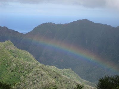
Photo by Brian Clarke


Photo by Brian Clarke
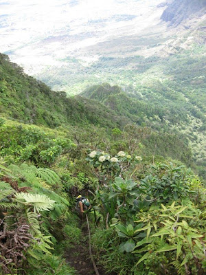
The climb has a lot of ropes, cords, garden hoses, printer cables for the steep, slippery sections.
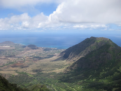

Photo by Brian Clarke
View of the Waianae valley/coast.
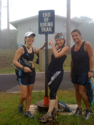

Photo by Cynthia Gibson
Me, Annie, and Linda.

Wednesday, August 5, 2009

Mango Madness: 6/13/2009


Mango Madness is the 3rd race in the 2009 HURT Trail Series. The course goes from the bottom to the top of the Tantalus trails. From the Nature Center, up Kanealole, Nahuina, the concrete Telephone road until the top at Puu Ohia. Then back down. The faster runners were thrown for a loop (literally) when the race marshalls made them go down Puu Ohia and up the Telephone road a second time, before continuing on the rest of the course.

Annie and I were out for a training run, not a race, so we volunteered to do the extra loop. The race marshalls were shocked - they couldn't believe we wanted to go up the Telephone road again. Annie and I had a great run. And the smiling reactions from the race marshalls and aid station volunteers made it even better.

Click the map or link below to go to the Garmin Connect site.
http://connect.garmin.com/player/8590047
1. In the map image on the Garmin site, select the "Hybrid" box
2. Press the "Play" button


Sat, 6/13/09
Start: Nature Center
2:25 / 9.5 miles / 15:09 avg


Photo by HURT Hawaii
Annie & I near the top of the concrete Telephone road.


Photo by HURT Hawaii
Brad finishing the race.


Photo by Brian Clarke
David, Ramon, Linda, Cindy, Annie, Brian, me, and Jack.


The HURT Hawaii website has the event write-up, race results, info on the cool keychains we got, and links to lots of race pictures. Including pics of: David, Jack, Brian, Ramon, Cindy, Melani, Linda, Ruby & Loren, Byron & Marji, and Benita . Thanks HURT!

Tuesday, August 4, 2009

Brian Clarke's Trail Training: 2009, week 9


Click the map or link below to go to the Garmin Connect site.
http://connect.garmin.com/player/8589461
1. In the map image on the Garmin site, select the "Hybrid" box
2. Press the "Play" button


Mon, 6/1/09
Start: Nature Center
Trails: Kanealole - Nahuina - Telephone rd - Puu Ohia - Parking #3 - Parking #2 - back
1:48 / 5.9 miles / 18:29 avg
We did the long uphill route that is the start of the Mango Madness course. In the map, you can see that the trails are easily accessible from the more densely populated areas of Honolulu.


Click the map or link below to go to the Garmin Connect site.
http://connect.garmin.com/player/8589561
1. In the map image on the Garmin site, select the "Terrain" box
2. Press the "Play" button


Wed, 6/3/09
Start: Manoa Falls
Trails: Manoa Falls - Ahuialama - Pauoa Flats - Kalawahine - Nahuina - Kanealole - Nature Center
1:48 / 5.7 miles / 19:11 avg
Continued uphill after Manoa Falls, then down to the Nature Center. Some of the runners continued on the roads back to the start of the Manoa Falls trail for a long, weeknight run.

Brian Clarke's Trail Training: 2009, week 8

To prepare for the upcoming Mango Madness race, we ran the Top of Tantalus loop twice this week: clockwise on Monday and counter-clockwise on Wednesday.

Click the map or link below to go to the Garmin Connect site.
http://connect.garmin.com/player/8588832
1. In the map image on the Garmin site, select the "Hybrid" box
2. Press the "Play" button


Mon, 5/25/09
Start: Parking #2
Trails: Telephone rd - Puu Ohia - Manoa Cliff - Moleka - Makiki Valley - Nahuina
1:30 / 4.7 miles / 19:10 avg


Click the map or link below to go to the Garmin Connect site.
http://connect.garmin.com/player/8588885
1. In the map image on the Garmin site, select the "Terrain" box
2. Press the "Play" button


Wed, 5/27/09
Start: Parking #2
Trails: Nahuina - Makiki Valley - Moleka - Manoa Cliff - Kalawahine
1:38 / 5.6 miles / 17:38 avg

Sunday, August 2, 2009

Brian Clarke's Trail Training: 2009, week 7

Click the map or link below to go to the Garmin Connect site.
http://connect.garmin.com/player/5999921
1. In the map image on the Garmin site, select the "Hybrid" box
2. Press the "Play" button


Wed, 5/20/09
Start: Jackass Ginger
Trails: Jackass Ginger - Nuuanu - Pauoa Flats - Lookout - back
1:54 / 3.9+ miles
We crossed Nuuanu Stream, then went up to the top of the ridge. After that, we continued on to the Pauoa Flats Lookout for a view of Kailua. For some reason, my Garmin didn't pick up the satellite signal until we got to the top of the ridge.


Click the map or link below to go to the Garmin Connect site.
http://connect.garmin.com/player/8588779
1. In the map image on the Garmin site, select the "Hybrid" box
2. Press the "Play" button


Sat, 5/23/09
Start: Pupukea
2:54 / 10.8 miles / 16:10 avg
First, we headed up the fire trail section. Looks like the Army has been doing a lot of work on the trail - grading it and putting down a layer of rocks. In some places, they've widened it and removed some of the hillside plants. We followed the trail until it ended up on a paved road. If you zoom in and pan further north in the map, you can see a network of other roads that it probably connects to. I hope they don't pave over the rest of the fire trail. On the way back, we went through the valley on the Kaunala trail.