Sunday, June 27, 2010

Raging Isle Sprint: 6/26/2010

First, a little background...

Garmin recently added a Swim mode software update for the Forerunner 310XT. There was a post about it on the Garmin blog, which also included a link to DC Rainmaker's blog.

Not only did DC Rainmaker have an incredibly in-depth review of the new Swim mode, but one of his earlier posts also shows how to swim with the Forerunner 305 in a swim cap!

Why didn't I think of that???

The Raging Isle Sprint is the first race in the 2010 North Shore Swim Series. I decided to try out the Garmin in a swim cap method.

I pretty much followed DC Rainmaker's tips:
- Remove the watch from the watchband
- Put the watch inside a ziploc bag
- Put the watch/ziploc bag on your head and put on your swim cap

I did have to make a few adjustments. The 405 has a bunch of sharp points and buttons and they kept poking holes in the ziploc bag, so I had to cushion all the pointy parts first (the 305 and 310XT are more square and their buttons are on top). Plus it was kinda hard to stuff the watch into my swim cap along with my ponytail. But Brad suggested putting the watch in the swim cap first, then putting the cap on my head. That was much easier.

The Swim

There was a North Shore swell on the day of the Raging Isle Sprint, so the race organizers put out buoys along the whole course to keep swimmers further outside and away from the shallow reef (and out of the way of the surfers).

When they sounded the horn, I pressed the Start button and started swimming. And kept swimming (just keep swimming...). It seemed like it took forever.

Then my watch beeped. At first, I thought I accidentally stopped it. But then I realized it was the 'Auto Lap' feature - I had swum a mile.

Raging Isle is supposed to be a 1-mile swim, but the Garmin recorded 1.2 miles. Surprisingly, the GPS route on the map looks pretty straight (when I'm swimming, I feel like I'm zig-zagging all over the place). And if you zoom in, you can really see the reef underwater.

Race Results can be found here.

Many THANKS to Jake from Garmin for alerting me to the new Swim mode, DC Rainmaker for the How To guide, and Raging Isle and Waikiki Swim Club for putting on a fun swim!

http://connect.garmin.com/player/38292439
1. In the map image on the Garmin site, select the "Hybrid" box
2. Press the "Play" button

Sat, 6/26/10
Start: Sunset Beach
Finish: Pipeline (Ehukai Beach Park)
0:52:35 / 1.0 miles / 3:17 per 100m

Friday, June 25, 2010

Jan's Birthday Run - Kaena Point

To celebrate Jan's Birthday, a group of us — Andy, Jan, Brad, Annie, Arvel, Lisa, Johnny, Benita, and me — went on a run at Kaena Point and had a potluck brunch afterwards. Jan's birthday was actually back in April - but it took me a while to put the run/potluck together. And even longer to post the pics and route.

Brad at the Point, with the Waianae range in the background.

At the Point, we saw a snoozing monk seal.
And a juvenile albatross.

Jan, Johnny, Andy

Annie, Lisa, Arvel

Johnny & Andy, along the coast

Everyone brought lots of good food! (photo by Johnny Landeza)

http://connect.garmin.com/player/37619867
1. In the map image on the Garmin site, select the "Hybrid" box
2. Press the "Play" button

Mon, 5/31/10
Start: End of Farrington Highway (North Shore)
Trails: Kaena Point: North Shore to Yokohama Bay (almost) and back
2:08 / 8.9 miles / 14:17 avg

Sunday, June 20, 2010

Run With A View: 5/8/2010, plus Peacock

Oops, I need to catch up on my posts...

Run With A View: Third race in the 2010 HURT Trail Series. In May.

008
View of Arizona Memorial (photo by Rob Lahoe)

As we started up the hill, there was a nice rain shower. I ran with Brad, Tai, Gordon, and Fish for awhile. Then we came across Jan, who was struggling with a strange, possibly allergy-induced, asthma attack. I stayed with Jan as she pulled herself back together and finished strong. Impressive.

http://connect.garmin.com/player/33419845
1. In the map image on the Garmin site, select the "Hybrid" box
2. Press the "Play" button

Sat, 5/8/10
Start: Pearl City
Trails: Kaahele
1:54 / 8.3 miles / 13:48 avg


Afterwards, Jan, Tai, and I headed up to Peacock for some more fun. We still had our race numbers from Run With A View on our legs. And people kept asking us how we got so dirty.

Julie, Tai, Jan

The three of us completed the Peacock 54-mile race together last October, so it was nice to be up there one last time before Tai moves away. And of course, there were the usual nice views.

Yokohama Bay

http://connect.garmin.com/player/33419908
1. In the map image on the Garmin site, select the "Hybrid" box
2. Press the "Play" button

Sat, 5/8/2010
Start: Dillingham Airfield
Trails: Kealia Trail - Kealia Fire Road - Crossover to three-way & back
2:39 / 7.0 miles / 22:32 avg

Wednesday, May 26, 2010

12 Hours of Makawao: 5/22/2010

Jan and I flew over to Maui for the 12 Hours of Makawao - a low-key event put on by the Valley Isle Road Runners at Kahakapao trail, a 6-mile loop in the Makawao Forest Reserve. Participants can run or mountain bike or both. For a few hours or all day.


Our original plan was to try to complete 8 loops (~49 miles) in 12 hours. But it turns out that the gate to the parking lot is only open from 7am-7pm. So realistically, that only gave us ~11 hours of running time.

Tom, the event director, graciously met us early and led us up the hill to the parking lot. We met some of the other runners and bikers and then were on our way at 7:20am.


Two of the local runners, Jackie and Marsha, were kind enough to show us the way on the first loop. It's a 0.5 mi dirt road from the parking lot to the Kahakapao trailhead. Then ~5.6 mi loop - up the East Loop to the top for the first half, then back down the West Loop. The trail has switchbacks up and down, so it's a gradual climb and a gradual downhill. Definitely a run-able grade, although we walked most of the uphills, since we were there all day.

The trail is very well-marked, with mile markers every half-mile and blue arrows on the trees to point the way. Since the trail is in the forest, the trail is leaves, pine needles, and soft dirt. A very forgiving surface and not at all rooty or rocky like Tantalus trails. And this past weekend, the trail was dry and in perfect condition.

Jan

Julie

http://connect.garmin.com/player/34599912
1. In the map image on the Garmin site, select the "Hybrid" box
2. Press the "Play" button


We would run 2 loops, then return to the car to restock. The Garmin route shows our first 4 loops (before the battery on my Forerunner 405 ran out). And the elevation map shows how consistently the trail is graded.

All in all: We completed 37 miles in 10.5 hours. On an amazing, amazing trail. At an easy, self-supported event. Can't wait for next year! Tom promises it'll be "even more low-key."

Splits (by loop):
1      1:28
2      1:41
break  0:05
3      1:39
4      1:41
lunch  0:19
5      1:59  (picture-taking loop)
6      1:44
Total: 10:36 / 37 miles / 17:11 avg

Gear:
- Asics Trabuco trail shoes
- Thorlo running socks
- Running Funky gaiters
- Camelbak (1.5L / 50 oz)
- 2 Clif bars
- 2 packs gummi bears
- 1 peanut butter and jelly sandwich
- 1/2 orange
- 2 bags pretzels
- McDonald's french fries (delivered by Brad and his Dad!)
- 11 Thermotabs / S-caps
- 75 oz (0.6 gal) Gatorade
- 75 oz (0.6 gal) water


The aftermath

Sunday, May 16, 2010

Haleiwa Metric Century Ride (4/09)

Here's the route from last year's Haleiwa Metric Century Ride. This year I was out of town and wasn't able to do it, but it's one of my favorite rides. Last year, my friends Mark and Jane were visiting, so Mark decided to do the Metric Century with me.

The Metric Century starts in Haleiwa and goes along the coast past Laie, out to Swanzy Beach Park in Kaaawa, and then back. And with the morning light over the water in so many places - you get so many super-amazing views.

http://connect.garmin.com/player/4414202
1. In the map image on the Garmin site, select the "Hybrid" box
2. Press the "Play" button

Sat, 4/26/09
Start: Kaiaka Bay Beach Park, Haleiwa
Turnaround: Swanzy Beach Park, Kaaawa
3:47 / 55.5 miles / 14.7 mpg avg


The Haleiwa Metric Century Ride is put on by the Hawaii Bicycling League (HBL). Their website has these very cool, point-of-view (POV) videos of what it's like to ride on streets on Oahu. Check out this video going up Monsarrat Ave:


For links to all Oahu Bicycle Routes.

You can also view the maps including bicycle crash data, such as:
Map 1. Downtown Honolulu, Ala Moana, University

Wednesday, April 14, 2010

Eco-Trail de Paris 50k - Lisa's race report

Lisa and her friend, Carol, flew to France to run a 50k trail race. The Eco-Trail de Paris 50k goes from Versailles to Paris and finishes at the base of the Eiffel Tower. How cool is that?


A few days before the race, Lisa emailed me a picture of her breakfast. I was drooling...
Petit dejeuner

Here's Lisa's race recap:

We finished! It was a mud fest and felt like 14 Hogsbacks in a row. Harder than the Volcano Marathon. I was doing good up to 40k @ 4:31, but then shuffled to the Eiffel Tower. Finished in 5:54. Carol was 5:36. Oh, we first had to walk a mile to catch the train to Versailles then walk 4k around Versailles Gardens to the race start line. So it was like a 55k! Lucky the rain stopped just as race started. It was a downpour for 15 hours before. The mud was crazy!

1 min. to START

at 10k - trudging up through the mud

Aid stations had chocolate! We are now having champagne and chocolate macarons.
Mmm, and fromage too

See attached Garmin data. You can see where the Garmin lost mileage in spikes of speed and I also recall looking at my Garmin 4-5 times and seeing it searching for satellites, lost signal.

4,500 feet of elevation gain (this is in garminconnect.com)....and when I downloaded to the Garmin Training software, it posted 7,000+ feet of elevation gain. It felt like 10,000!. Who knew if was going to be 20 times 200-foot hill gains. It was a Hogsback repeat race after all!


Race Required Gear:
- 2 liters water minimum (Nathan HPL Hydration 008 race vest with a 45+ oz Camelback bladder with electrolytes plus a Nathan 9 oz handheld bottle).
- Personal cup 15cl minimum
- Food supply (for me: 6 Tri-berry Gus, a few pretzel sticks, 1 pkg Clif Shots, 1 scoop Spiz)
- Rain Jacket
- Tights (CW-X)
- Trash keeper (race-provided mesh holder for your sports gu trash).
- Cell phone
- Reflective arm band
- Whistle
- Survival blanket!!!?
- Adhesive elastic band enabling you to make a bandage or strap (mini 80cm x 3 cm)
- Cap or bonnet (“buff”)
- Proof of identity (Road ID)
- Medical certificate (“fit for competitive running”)

Other personal gear:
- Salomon XA Pro 3D Ultra trail shoes
- Long-Sleeve jersey
- SmartWool socks
- Electrolyte tab and Advil
- Map of race course
- 10 euros

My gear + water stuffed into the Nathan vest weighed 6 lbs! But very comfortable the entire race.

Links:
- More of Lisa's Paris pictures
- Eco-Trail de Paris site
- Blog post from 80k 4th place finisher, Ian Sharman

All photos by Lisa Reinke.

Sunday, April 11, 2010

Top of Tantalus: 4/10/2010

Top of Tantalus: Second race in the 2010 HURT Trail Series. The course was nice and muddy. And Na Ala Hele did a great job of clearing the trees that had blown down recently.

The race starts with a sprint from the Lookout to the trailhead. Then, while you wait in the pile-up that occurs at the narrow opening to the trail, you can catch your breath before it's your turn to head down the steep hill. After running through 7 miles of hills, rocks, roots, and mud, you get to run up the same steep hill that you started down. I think I was crawling by the time I finally, finally reached the top.

Top of Tantalus 4-10-2010 124
Jack

Top of Tantalus 4-10-2010 136
Julie

Top of Tantalus 4-10-2010 160
Jan

http://connect.garmin.com/player/29642678
1. In the map image on the Garmin site, select the "Terrain" box
2. Press the "Play" button

Sat, 4/10/10
Start: Puu Ualakaa State Park
Trails: Ualakaa - Makiki Valley - Nahuina - Kalawahine - Manoa Cliff - Moleka - Makiki Valley - Ualakaa
1:26 / 6.6 miles / 12:58 avg

More stuff on the HURT Hawaii site:
- Race Results and Rob's pics
- Mike's pics

Race photos by Rob Lahoe.

Monday, April 5, 2010

Ford Island Bridge 10k: 4/3/2010

Saturday was the Ford Island Bridge 10k race. This is one of Brad's and my favorite races - and one of the few road races that I do. We've run it every year since 2004, except for 2006. There's something cool about running across the bridge and around the old airfield.

This year's race was pretty fun. Brad and I ran it together, but he could've had a faster time. Afterwards, we saw Jan, Andy, and Johnny. And had free popsicles from Meadow Gold. Then we went to Liliha Bakery for breakfast. Pancakes. Yum.

http://connect.garmin.com/player/29017277
1. In the map image on the Garmin site, select the "Hybrid" box
2. Press the "Play" button

Sat, 4/3/10
Ford Island Bridge 10k
53:00 / 6.2 miles / 8:34 avg


On Thursday, Lisa, Jack, Alec, and I ran up on Tantalus. Throughout the run, we were amazed by the number of large trees that had been knocked down by the recent winds. It was like a tornado went through. Or a bulldozer.

Lisa brought chocolates from Paris to share. There were these homemade chocolate-covered marshmellows - they were super-light. And from Germany, some dark chocolate with mint - super-smooth. Thanks for sharing, Lisa!

http://connect.garmin.com/player/29016960
1. In the map image on the Garmin site, select the "Terrain" box
2. Press the "Play" button

Thu, 4/1/10
Start: Parking #2
Trails: Kalawahine - Manoa Cliff - Pauoa Flats - Kalawahine
0:50 / 3.1 miles / 16:19 avg

Thursday, April 1, 2010

Peacock

This weekend Jan and I headed up to Peacock. We can't get enough of the place. Rex joined us. Mike too. And we ran into Cheryl and Benita while they were up there.

Rex brought up the topic of the word "dude." And on the way down the switchbacks at Kealia, we got into a discussion about how "dude" can mean so many things.

Like "Happy surprise" dude:
Dude #1: "I brought you a case of beer."
Dude #2: "DUDE!"

Or "I know you're lying" dude:
Dude #1: "Did you drink the last beer?"
Dude #2: "No."
Dude #1: "Duuuuude..."

The route of our run is below. Fun times, dude.

http://connect.garmin.com/player/28507635
1. In the map image on the Garmin site, select the "Hybrid" box
2. Press the "Play" button

Sat, 3/27/10
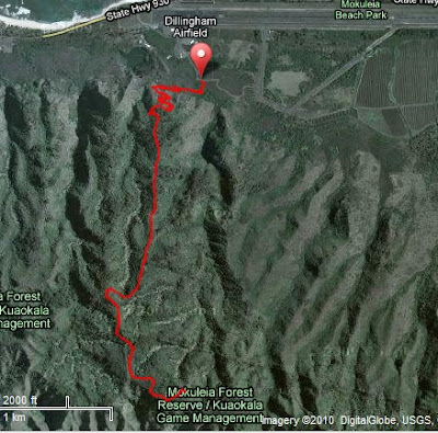
Start: Dillingham Airfield
Trails: Kealia - Access Road West - Kuaokala - Crossover out & back - Kealia
5:20 / 20.2 miles / 15:50 avg

Tuesday, March 23, 2010

Moanalua 6-mile: 3/20/2010

Saturday was the first race in the 2010 HURT Trail Series. The Moanalua 6-mile is a new race and was added to the series this year. It is also a fundraiser for the HPU Cross Country team.

The trail goes into the back of the Moanalua Valley and climbs gradually until the turnaround. Brad and I ran the race together. He wanted to track his heart rate during the race, but I like knowing how far we've run. Since we were running together, he wore the heart rate monitor and I wore the Garmin watch.

See the HURT site for the race write-up, including results and pics.

http://connect.garmin.com/player/27887137
1. In the map image on the Garmin site, select the "Hybrid" box
2. Press the "Play" button

Sat, 3/20/10
Start: Moanalua Valley
Trails: Moanalua Valley (out & back)
1:00 / 6.1 miles / 9:52 avg


On Thursday, Jan, Euvy, and I ran the Moanalua Valley trail, so we could get a preview before the race. The trail was muddy and a lot of the stream crossings were pretty wet. On the way out, we tried to step our way across the stream crossings. But on the way back, we pretty much just steeplechase-jumped our way across. On race day, we lucked out and it was a lot drier.

The preview must've helped Jan. She had a great race on Saturday!

http://connect.garmin.com/player/27426157
1. In the map image on the Garmin site, select the "Terrain" box
2. Press the "Play" button

Thu, 3/18/10
Start: Moanalua Valley
Trails: Moanalua Valley (out & back)
1:33 / 7.2 miles / 12:55 avg

Sunday, March 14, 2010

Hogsback Loops, Reverse Gordon's Loop, and State Park

This was the week for loops. First, Alec, Jan, and I did some Hogsback Loops. Alec and I ran together. Jan got there a little late, but burned through the first loop in 36:39!

http://connect.garmin.com/player/27034724
1. In the map image on the Garmin site, select the "Terrain" box
2. Press the "Play" button

Thu, 3/11/10
Start: Nature Center
Trails: Hogsback (Maunalaha) - Makiki Valley - Center (Kanealole). 2x.
1:33 / 4.7 miles / 19:45 avg


On Saturday, it was time for more Peacock. Jan, Johnny, and I had a great time. We decided to run Gordon's Loop in reverse. It's funny how when you run a familiar route backwards, it's practically like a brand-new trail.

Also, there'd been some recent talk on the HURT blog about "vicious" girls, who "give no quarter." But Johnny will tell you that when we found a quarter during the run, we let him have it. See, we're not that vicious. Really.

http://connect.garmin.com/player/27034928
1. In the map image on the Garmin site, select the "Terrain" box
2. Press the "Play" button

Sat, 3/13/10
Start: Dillingham Airfield
Trails: Kealia - Kuaokala - Access Road West - Kealia
3:43 / 12.6 miles / 17:37 avg


Then on Sunday, Brad and Jonathan started at the State Park and did a Hogsback Loop. Brad said it was a good day on the trails. It was Jonathan's first time on the trails, so hopefully he'll be back for more.

http://connect.garmin.com/player/27048207
1. In the map image on the Garmin site, select the "Hybrid" box
2. Press the "Play" button

Sun, 3/14/10
Start: State Park
Trails: Ualakaa - Makiki Valley - Center (Kanealole) - Hogsback (Maunalaha) - Ualakaa
1:12 / 3.5 miles / 20:23 avg

Wednesday, March 10, 2010

Kalawahine and Peacock Flats

This week, Alec came out to run. Alec is a cancer survivor and it was great to see him out on the trails again!

http://connect.garmin.com/player/26605949
1. In the map image on the Garmin site, select the "Hybrid" box
2. Press the "Play" button

Thu, 3/4/10
Start: Parking #2
Trails: Kalawahine - Manoa Cliff - Puu Ohia - Tantalus Road - Parking #2 - Concrete Road (up & back)
1:08 / 3.9 miles / 17:43 avg


Then on Saturday, Jan and I went to run up at Peacock Flats. I'd been dying to get out there - especially since I didn't make there last week. The views were amazing! As you can see from the map, you are surrounded by views of the ocean. Peacock is definitely one of my favorite places to run on the island.

http://connect.garmin.com/player/26606120
1. In the map image on the Garmin site, select the "Hybrid" box
2. Press the "Play" button

Sat, 3/6/10
Start: Dillingham Airfield
Trails: Kealia - Access Road West - Kuaokala - Crossover out & back - Access Road West - Kealia
4:38 / 15.5 miles / 17:59 avg

Tsunami Warning, Then Some Trails to the State Park

On Sat, Feb 27, 2010 at 6am, we were awakened by civil defense sirens, followed by an announcement over the building intercom that this was not a drill. Then at 6:15am, my parents called from California to make sure we were awake. Actually, I had known about the impending tsunami since the night before, since I'd been up watching the Olympics.

The tsunami was expected to arrive in Honolulu at 11:37am. Check out this cool map that shows the earthquake in Chile and predicts how the potential tsunami would radiate outward.

Map from NOAA

Brad and I topped off the gas tank in my car and then went to Safeway to stock up. Combining our existing emergency supplies with our newly-purchased food, we felt pretty prepared and sat on the lanai to watch and wait.


First, we saw all the boats leaving the harbor. Pretty cool - I've never seen so many boats out on the water.


From 11:30am to 1:30pm, we saw about 4 'waves.' The water would go out and expose a large part of the reef at Ala Moana Beach Park. Then the water would come back in and cover the reef. Then the cycle would start again. Usually when the water going out and coming in is due to the tide, it takes a long time to expose/cover the reef. But from the tsunami, it happened much faster - in a few minutes. And there was only 20 minutes between the water going out and the water coming back in.

This time-lapse video from KHON shows the water at Ala Moana coming in and going back out (CNN mislabeled it as Hilo).


Luckily, there wasn't much impact of the tsunami in Hawaii (or elsewhere). And after the tsunami warning was cancelled, I went on with my plans to run up at Peacock Flats. However, my car had other ideas and freaked out on the freeway, so I had to turn around and go home. Later Brad drove us up to Tantalus, and we went for a run to the State Park. The lookout was still full of people, who had gone up there for a high vantage point for the tsunami.

http://connect.garmin.com/player/26102539
1. In the map image on the Garmin site, select the "Hybrid" box
2. Press the "Play" button

Sat, 2/27/10
Start: Nature Center
Trails: Hogsback - Ualakaa (to State Park & back) - Makiki Valley (to Moleka & back) - Makiki Valley - Kanealole
1:12 / 4.3 miles / 16:42 avg

Wednesday, February 24, 2010

Pali Lookout (Maunawili trail)

On Saturday, Lisa, Jan, and I decided to meet at the Pali Lookout for a run on the Maunawili trail. Jack came along too and brought a surprise guest: Kristin, who was visiting from Boulder. Newcomer Robert joined too. The weather was pretty good - no rain and not too hot. The trails were a little muddy and slippery, due to the rain the night before.

http://connect.garmin.com/player/25484760
1. In the map image on the Garmin site, select the "Terrain" box
2. Press the "Play" button

Sat, 2/20/10
Start: Pali Lookout
Trails: Maunawili (out & back)
3:19 / 12.1 miles / 16:26 avg